 TemperateReefBase Geonetwork Catalogue
Conservation and Biodiversity
Type of resources
Topics
Keywords
Contact for the resource
Provided by
Years
-
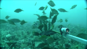
The Flinders CMR survey was a pilot study undertaken in August 2012 as part of the National Marine Biodiversity Hub's National monitoring, evaluation and reporting theme. The aim of this theme is to develop a bluepint for the sustained monitoring of the South-east Commonwealth Marine Reserve Network. The particular aims of the survey were twofold; 1) to contribute to an inventory of demersal and epibenthic conservation values in the reserve and 2) to test methodologies and deployment strategies in order to inform future survey design efforts. Several gear types were deployed; including multibeam sonar, shallow-water (less than 150m) Baited Remote Underwater Video (BRUVs), deep- water BRUVs, towed video and digital stereo stills. This resource contains the shallow-water BRUV footage captured on the FLinders CMR shelf (less than 150 m). Stereo BRUV's were deployed using a probabalistic and spatially-balanced survey design called Generalized Random Tessellation Stratified (GRTS). Habitats were identified in a previous multibeam survey and consisted of 'mixed reef' (containing patchy reef) and sand. Mixed reef habitat was targeted in this survey (9 GRTS mixed reef sites versus 3 sand sites). A total of 60 stereo BRUVs were deployed. Data contained here represents footage collected using these drops and the associated scored data (abundance (MaxN) and lengths).
-
The Tasman Fracture CMR AUV survey was a pilot study undertaken in 2014/15 as part of the National Marine Biodiversity Hub's National monitoring, evaluation and reporting theme. The aim of this theme is to develop a bluepint for the sustained monitoring of the South-east Commonwealth Marine Reserve Network. The particular aim of the survey was to contribute to an inventory of the distribution and abundance of demersal fishes in the reserve and adjacent reference sites using BRUVs. Data contained here represents footage collected using these drops and the associated scored data (abundance and lengths).
-
These data describe quantitative exposure indices generated using cartographic fetch methods on a 0.01 degree grid across temperate Australia (South Australia, Victoria and Tasmania). Two indices are reported: openness and bathymetry-altered fetch. Openness is a measure of the distance of a site to the nearest coastline in all directions and describes potential exposure to locally generated seas and undefined swell. Bathymetry-altered fetch attempts to account for the attenuation of wave energy as waves move into shallow waters and encounter friction with the seafloor.
-
The Tasman Fracture CMR AUV survey was a pilot study undertaken in 2014/15 as part of the National Marine Biodiversity Hub's National monitoring, evaluation and reporting theme. The aim of this theme is to develop a blueprint for the sustained monitoring of the South-east Commonwealth Marine Reserve Network. The particular aim of the survey was to contribute to an inventory of the distribution and abundance of southern rock lobster (Jasus edwardsi). Data contained here represents the data collected from lobster potting component of the study. This includes lobster abundance, gender and length. Bycatch is also recorded.
-
The Tasman Fracture CMR AUV survey was a pilot study undertaken in 2014/15 as part of the National Marine Biodiversity Hub's National monitoring, evaluation and reporting theme. The aim of this theme is to develop a bluepint for the sustained monitoring of the South-east Commonwealth Marine Reserve Network. The particular aim of the survey was to contribute to an inventory of the distribution and cover of epibenthic biota in the reserve using IMOS AUV 'Sirius'. Data contained here represents a scored subset of the ~ 18,400 images collected at the Tasman Fracture CMR. Images were scored for proportion cover of visible macrobiota using 25 random points superimposed on each image. Taxon were biologically classified using UTAS morphospecies classification scheme, which can be mapped back to CATAMI (http://catami.org/).
-
Data accompanying Layton et al. 2019, Resilience and stability of kelp forests: the importance of patch dynamics and environment-engineer feedbacks. PLOS ONE. To explore how resilience and stability of kelp habitats is influenced by this habitat degradation, we created an array of patch reefs of various sizes and supporting adult Ecklonia radiata kelp transplanted at different densities. This enabled testing of how sub-canopy abiotic conditions change with reductions in patch size and adult kelp density, and how this influenced demographic processes of microscopic and macroscopic juvenile kelp.
-
The Flinders CMR AUV survey was a pilot study undertaken in June 2013 as part of the National Marine Biodiversity Hub's National monitoring, evaluation and reporting theme. The aim of this theme is to develop a blueprint for the sustained monitoring of the South-east Commonwealth Marine Reserve Network. The particular aim of the survey was to contribute to an inventory of the distribution and cover of epibenthic biota in the reserve using IMOS AUV 'Sirius'. Data contained here represents a scored subset of the ~ 36,700 images collected at the Flinders CMR. Images were scored for proportion cover of visible macrobiota using 25 random points superimposed on each image. Taxon were biologically classified using CATAMI (http://catami.org/).
-
Water quality and biological data was collected from four tide-dominated river estuaries indicative of catchments with varying levels of human impacts to: 1) assess draft indicator levels for water quality, and 2) investigate biological indicators of estuarine health in NW Tasmania. This data includes sampling from Detention River, Duck Bay, Montagu River and Black River
-
Water quality and biological data was collected from four tide-dominated river estuaries indicative of catchments with varying levels of human impacts to: 1) assess draft indicator levels for water quality, and 2) investigate biological indicators of estuarine health in NW Tasmania. The data represented by this record was collected in the Black River.
-
Water quality and biological data was collected from four tide-dominated river estuaries indicative of catchments with varying levels of human impacts to: 1) assess draft indicator levels for water quality, and 2) investigate biological indicators of estuarine health in NW Tasmania. The data represented by this record was collected in the Montagu River.